Alaska is just huge. Seriously, trying to see it all from a car or on foot is pretty much impossible. So much of it is just wild, with mountains and forests that go on forever. That’s why getting up in the air is really the only way to get a true sense of the place. You can take a simple flightseeing tour to see glaciers, or you can look into the more serious work done by aerial survey companies. They use planes and helicopters for all sorts of things, from mapping the land to helping out big industries. This article will cover all of it, from the fun flights to the important survey work.
Key Takeaways
- Seeing Alaska’s huge, wild areas is best done from a plane or helicopter since so much is unreachable by road.
- It’s not all about tourism; aerial survey companies do important work mapping terrain and supporting industries like oil and gas.
- For an unforgettable trip, you can book a flightseeing tour to see glaciers and national parks or even try something like heli-skiing.
- Safety is a big deal in Alaskan aviation, so always check a company’s certifications and the experience of its pilots.
- When planning your flight, consider the time of year and make sure you book with a reputable company that knows the local conditions.
The Unique Perspective Of An Alaskan Aerial View
Why The Last Frontier Is Best Seen From The Sky
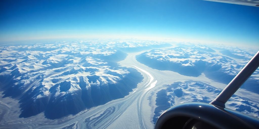
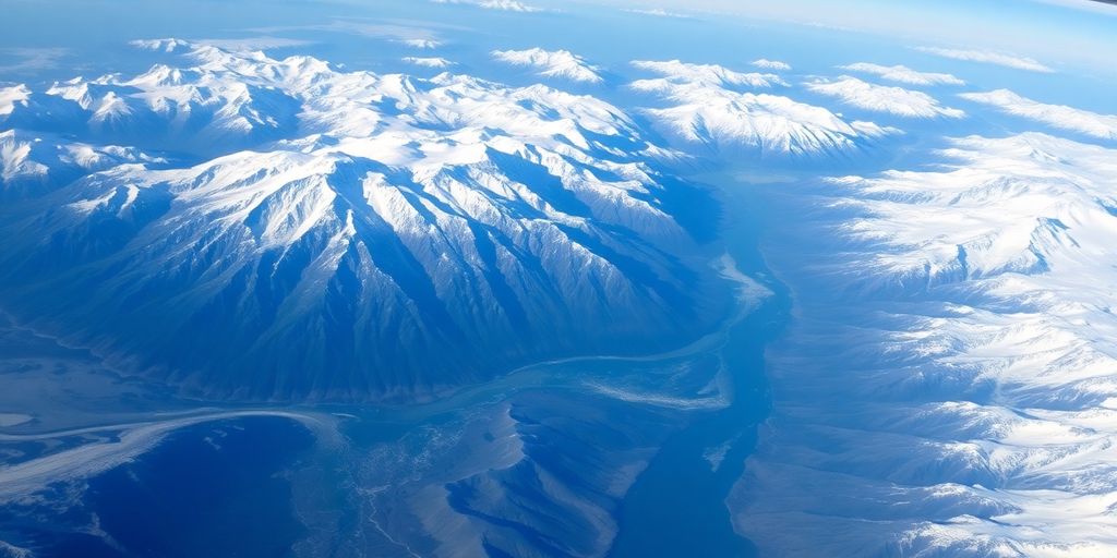
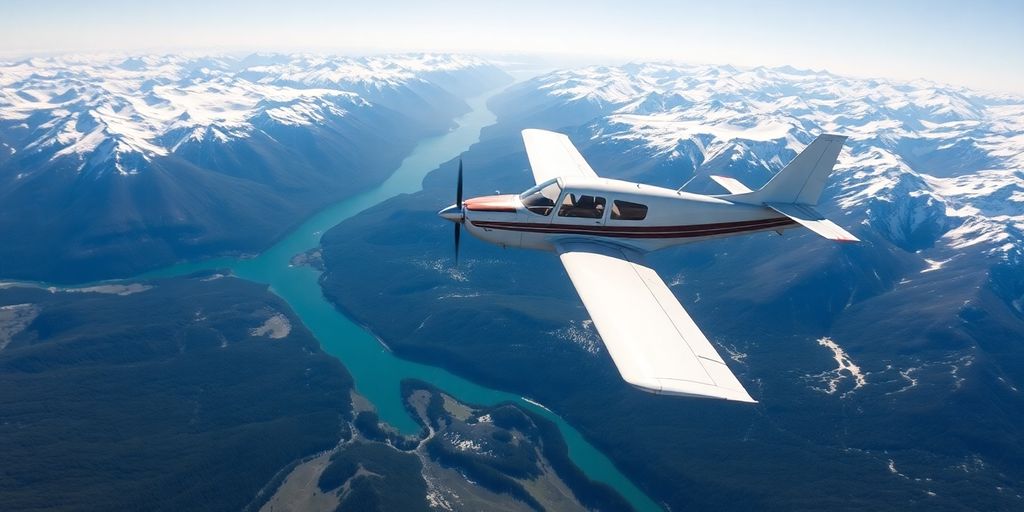
Alaska is huge. Like, ridiculously huge. You can drive for days and still not see everything. That’s why seeing it from above is so special. It gives you a sense of scale that you just can’t get on the ground. Imagine seeing mountain ranges stretch out forever, or glaciers carving their way through the land. It’s a totally different experience than just driving through a forest. Plus, you get to see things that are completely inaccessible by road. Think hidden lakes, remote valleys, and wildlife roaming free. It’s like unlocking a secret level of Alaska.
- Vastness becomes tangible.
- Inaccessible areas are revealed.
- Wildlife sightings are enhanced.
A Glimpse Into Alaska’s Vast And Untamed Wilderness
From the air, Alaska transforms into a living map. You can trace the paths of rivers, see how forests give way to tundra, and understand the sheer remoteness of certain areas. It’s not just about pretty views (though there are plenty of those!). It’s about understanding the landscape in a way that’s impossible from the ground. You start to appreciate how everything is connected, from the smallest stream to the highest peak. It’s a humbling experience, to say the least. Check out this aerial photography gallery to see what I mean.
The Critical Role Of Aviation In Alaskan Life
Aviation isn’t just a fun tourist activity in Alaska; it’s a lifeline. Many communities are only accessible by air, making planes and helicopters essential for everything from delivering mail to transporting medical supplies. It’s a different world up there, where pilots are the unsung heroes connecting people and places. Heli Alaska, Inc. is one of the companies that provides these services. The pilots need rigorous training for flying in Alaska. It’s not just about knowing how to fly; it’s about understanding the weather, the terrain, and the unique challenges of navigating such a vast and unforgiving landscape.
Living in Alaska, you quickly realize how much the state depends on aviation. It’s not just a convenience; it’s a necessity. Without planes, many communities would be completely isolated. It’s a testament to the skill and dedication of the pilots who keep Alaska connected.
Choosing The Right Aerial Survey Companies In Alaska
Alaska’s vastness demands careful selection when it comes to aerial survey companies. It’s not just about getting a service; it’s about finding a partner who understands the unique challenges and opportunities presented by the Alaskan landscape. Let’s break down what to consider.
What To Look For In Professional Aerial Survey Services
When you’re looking for an aerial survey company, start with the basics. Do they have the right equipment for your project? Are they experienced in the specific type of survey you need, whether it’s for infrastructure, environmental monitoring, or something else? A good company will have a proven track record and be able to clearly explain their process. Don’t be afraid to ask for case studies or examples of similar projects they’ve completed. Also, make sure they have adequate insurance coverage. You want to be protected in case something goes wrong. Finally, consider their communication style. Are they responsive and easy to work with? Good communication is key to a successful project.
Comparing Local Expertise With Advanced Technology
In Alaska, local knowledge is just as important as having the latest technology. A company might have the fanciest drones and sensors, but if they don’t understand the local weather patterns, terrain, and regulatory environment, they’re going to struggle. Look for a company that balances cutting-edge technology with a deep understanding of Alaska. They should be able to adapt their approach based on the specific conditions of your project site. For example, a company familiar with the area around GPS Alaska can provide more efficient surveys.
Key Certifications And Safety Records For Alaskan Operators
Safety is paramount in Alaskan aviation. Before hiring an aerial survey company, thoroughly check their certifications and safety record. Are they FAA certified? Do they have a comprehensive safety management system in place? Ask about their pilot training programs and maintenance procedures. A company committed to safety will be transparent about their practices and willing to provide documentation. Look for companies like Heli Alaska, Inc. that prioritize safety and have a strong reputation in the industry. Don’t hesitate to ask for their safety statistics and incident reports. Your project’s success shouldn’t come at the expense of safety.
The Technology Behind Modern Aerial Surveys
High-Resolution Imaging And Photogrammetry
Aerial surveys have come a long way, and it’s pretty cool to see how much tech is involved. High-resolution imaging is a big deal, allowing for super detailed pictures of the ground. Photogrammetry then takes these images and turns them into 3D models. It’s like taking a bunch of photos from different angles and stitching them together to create a complete picture. This is useful for all sorts of things, from mapping terrain to inspecting infrastructure.
LiDAR And 3D Mapping Of Rugged Terrain
LiDAR is another game-changer. It stands for Light Detection and Ranging, and it works by shooting laser beams at the ground and measuring how long it takes for them to bounce back. This gives you super accurate elevation data, which is perfect for creating 3D maps, especially in places like Alaska where the terrain can be really rough. With LiDAR, you can see through vegetation and get a clear picture of the ground underneath. This is a huge help for things like resource exploration and environmental monitoring. You can use LiDAR mapping technology to create accurate maps.
Specialized Equipment For Challenging Alaskan Conditions
Alaska is a tough place to work, so you need special equipment for aerial surveys. This means planes and helicopters that can handle the weather, as well as sensors that can deal with the cold and the snow. It also means having experienced pilots and crews who know how to fly in these conditions.
The equipment used in Alaskan aerial surveys is not your average gear. It’s built to withstand extreme temperatures, high winds, and unpredictable weather patterns. This ensures that data collection is accurate and reliable, no matter the conditions.
Here’s a quick rundown of some of the specialized equipment:
- Aircraft: Modified planes and helicopters with enhanced navigation systems.
- Sensors: High-resolution cameras, LiDAR scanners, and thermal sensors.
- Software: Advanced processing software for creating 3D models and maps.
Commercial Applications For Aerial Survey Companies
Supporting The Oil And Gas Sector
Aerial surveys play a big role in the oil and gas industry, especially in a place like Alaska. Think about it: you need to map out potential drilling sites, monitor pipelines for leaks or damage, and keep an eye on the environmental impact of operations. Aerial surveys provide a fast and efficient way to gather this data, often in areas that are hard to reach by ground. For example, LiDAR technology can create detailed 3D models of the terrain, helping companies plan infrastructure projects with precision. Heli Alaska, Inc. provides aerial surveying services to support these activities.
Environmental Monitoring And Wildlife Management
Alaska’s vast wilderness is home to a lot of wildlife, and keeping track of it all is a big job. Aerial surveys help with that too. They can be used to:
- Track animal populations and migration patterns.
- Monitor the health of ecosystems.
- Assess the impact of human activities on the environment.
It’s not just about counting animals, though. Aerial surveys can also help detect pollution, monitor deforestation, and assess the damage from natural disasters like wildfires. This information is important for making informed decisions about conservation and resource management.
Infrastructure Planning And Resource Exploration
Before you can build anything, you need to know what’s there. Aerial surveys are used to map out the terrain, identify potential hazards, and locate resources like minerals and water. This is important for:
- Planning new roads, bridges, and pipelines.
- Identifying suitable locations for buildings and other structures.
- Assessing the feasibility of resource extraction projects.
For example, high-resolution imaging and photogrammetry can be used to create detailed maps of the area, helping engineers and planners make informed decisions. Drones enhance mapping and surveying by rapidly capturing precise data over large areas. Drone surveying is a technique widely used in industries such as construction, mining, agriculture, land development, and infrastructure management.
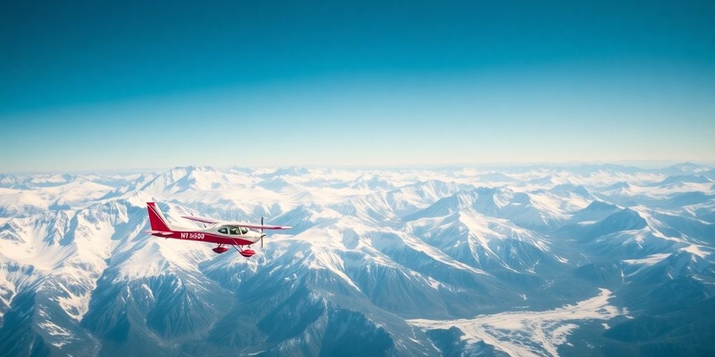
Beyond The Survey: Unforgettable Flightseeing Tours
Alaska’s beauty isn’t just something you read about; it’s something you experience. And what better way to soak it all in than from the sky? While aerial survey companies are busy mapping and analyzing the land, other aviation companies are dedicated to showing off Alaska’s most stunning sights. These flightseeing tours offer a completely different perspective, turning the Alaskan wilderness into a breathtaking spectacle.
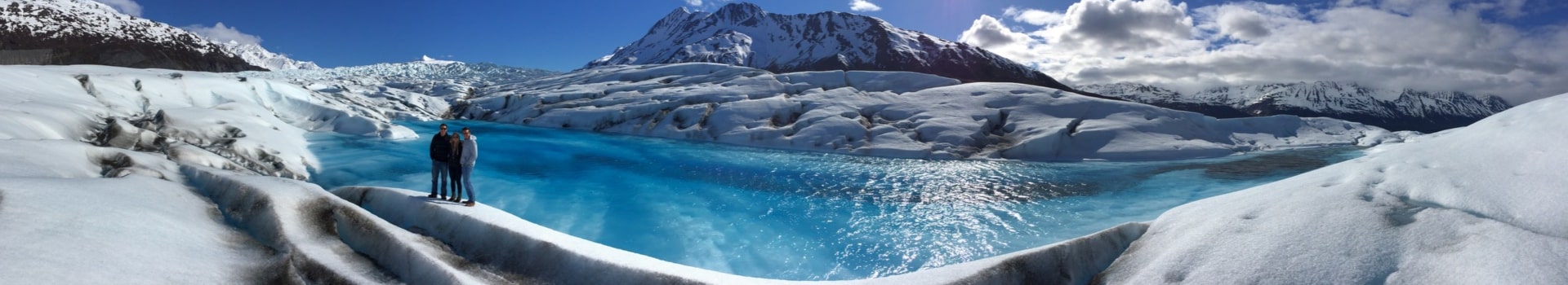
Soaring Over Glaciers And Majestic Icefields
Imagine gliding over fields of ice, where glaciers carve their way through the landscape. Flightseeing tours make this dream a reality. You’ll witness the sheer scale and beauty of these natural wonders, seeing crevasses, icefalls, and the stunning blue hues of ancient ice. It’s an experience that puts the power and grandeur of nature right before your eyes. For example, you can explore Alaska from a unique aerial perspective.
Denali National Park From A Bird’s-Eye View
Denali National Park is vast, and seeing it all on foot would take a lifetime. A flightseeing tour offers a shortcut to the heart of the park, giving you panoramic views of Denali (formerly Mount McKinley) and the surrounding peaks. You’ll see the braided rivers, the tundra stretching to the horizon, and maybe even spot some wildlife from above. It’s a perspective that truly captures the scale of this iconic wilderness. You can experience the majestic Alaskan wilderness from above.
Coastal Tours And Marine Wildlife Spotting
Alaska’s coastline is just as impressive as its mountains. Coastal flightseeing tours take you over rugged cliffs, secluded beaches, and the vast expanse of the ocean. Keep an eye out for marine wildlife – whales, seals, and sea otters are often spotted from above. It’s a chance to see Alaska’s marine ecosystems in action, all from the comfort of your aircraft. Seawind Aviation offers floatplane tours from Ketchikan.
Flightseeing tours are more than just scenic flights; they’re immersive experiences that connect you with Alaska’s natural wonders. The views are incredible, the perspective is unique, and the memories will last a lifetime. It’s a must-do for anyone wanting to truly appreciate the Last Frontier.
Specialized Helicopter Services Across The State
Heli-Skiing And Backcountry Adventures
Alaska’s vast, untouched wilderness makes it a prime location for heli-skiing and other backcountry adventures. Helicopters provide access to remote, pristine slopes that are otherwise inaccessible, opening up a world of possibilities for experienced skiers and snowboarders. These services often include:
- Transportation to and from the slopes.
- Experienced guides familiar with the terrain and snow conditions.
- Safety equipment and training.
It’s important to remember that heli-skiing is an extreme sport, and participants should be in excellent physical condition and have a high level of skiing or snowboarding ability. Always choose a reputable operator with a strong safety record.
Remote Lodge And Camp Transportation
Getting to remote lodges and camps in Alaska can be a challenge, but helicopters offer a convenient and efficient solution. Many lodges and camps rely on helicopter charter services to transport guests, staff, and supplies. This is especially true for locations that are not accessible by road or boat. Heli Alaska, Inc. is one of the companies that provide this service.
Aerial Photography And Cinematography Workshops
Alaska’s stunning landscapes make it a dream destination for photographers and filmmakers. Helicopter services can be chartered for aerial photography and cinematography, providing unique perspectives and angles that are impossible to achieve from the ground. Some companies even offer specialized workshops that combine flightseeing with photography instruction. These workshops typically include:
- Instruction from experienced aerial photographers.
- Guidance on camera settings and techniques.
- Opportunities to photograph glaciers, mountains, and wildlife from the air.
Meet The Experts: Profiles Of Alaskan Pilots And Crews
The Rigorous Training For Flying In Alaska
Flying in Alaska isn’t like hopping on a plane anywhere else. It’s a whole different ballgame. The weather can change in a heartbeat, the terrain is unforgiving, and you’re often flying over vast stretches of wilderness. That’s why the training for pilots here is so intense. It’s not just about logging hours; it’s about mastering skills that could save your life.
- Mountain flying techniques
- Survival skills
- Extensive weather training
Alaskan pilots need to be ready for anything. They need to know how to handle whiteout conditions, navigate through narrow mountain passes, and land on remote gravel strips. It’s a demanding job, but it’s also incredibly rewarding.
Stories From Veteran Pilots Of The North
Talk to any veteran pilot in Alaska, and they’ll have stories that’ll make your hair stand on end. Tales of daring rescues, close calls with wildlife, and flights that pushed them to their limits. These aren’t just pilots; they’re legends of the sky. You can find some of these stories on a Quora page about pilots.
The Importance Of Local Knowledge And Experience
In Alaska, local knowledge is everything. It’s not enough to be a skilled pilot; you need to understand the nuances of the Alaskan landscape. You need to know where the best landing spots are, how the wind behaves in different valleys, and what to expect from the local wildlife. Heli Alaska, Inc. is a veteran owned company that understands the importance of local knowledge.
Here’s why local experience matters:
- Understanding microclimates
- Knowing the best routes
- Building relationships with local communities
| Factor | Importance |
|---|---|
| Microclimates | Critical for predicting weather changes and avoiding dangerous conditions. |
| Best Routes | Ensures efficient and safe travel, avoiding hazardous terrain. |
| Local Relations | Helps in emergency situations and provides support in remote areas. |
Planning Your Alaskan Aerial Adventure
Best Seasons For Flightseeing And Aerial Work
When’s the best time to take to the skies in Alaska? Well, it really depends on what you’re hoping to see and do. For flightseeing, summer (June-August) is prime time. You’ll get long daylight hours and relatively mild weather, making for smoother flights and better visibility. This is when most tours operate, so you’ll have the most options. However, be prepared for crowds and higher prices. For aerial work, like surveys, the shoulder seasons (May and September) can be ideal. The weather is still decent, but there are fewer tourists, and you might find better deals. Plus, the fall colors can be spectacular!
Booking Your Tour Or Charter Service
Booking your Alaskan aerial adventure requires a bit of planning. Start by researching different companies and reading reviews. Look for operators with good safety records and experienced pilots, like Heli Alaska, Inc.. Decide what you want to see – glaciers, Denali, wildlife – and choose a tour that fits your interests. Book well in advance, especially if you’re traveling during peak season. For charter services, clearly communicate your needs and objectives to the company. This ensures they can provide the right aircraft and equipment for your specific project. Don’t hesitate to ask questions about their experience, certifications, and safety protocols.
What To Expect On Your Flight
So, you’ve booked your flight – what’s next? First off, dress warmly in layers, even in summer. Temperatures can change quickly at altitude. Wear comfortable shoes and bring sunglasses. Most tours provide headsets so you can hear the pilot’s commentary. Be prepared for some turbulence, especially in mountainous areas. Don’t forget your camera! The views are incredible, and you’ll want to capture them. Listen carefully to the pilot’s safety briefing and follow their instructions. And most importantly, relax and enjoy the ride! You’re about to witness some of the most breathtaking scenery on Earth. Consider a one-hour flightseeing tour to get a taste of the Alaskan landscape.
Remember to confirm your booking details a day or two before your flight. Check the weather forecast and be prepared for potential delays or cancellations due to inclement conditions. Flexibility is key when traveling in Alaska. Also, be aware of any weight restrictions or baggage limitations imposed by the tour operator.
Here’s a quick checklist to help you prepare:
- Confirm booking details.
- Check the weather forecast.
- Dress in warm layers.
- Bring your camera and sunglasses.
- Listen to the safety briefing.
Safety First: Understanding Aviation Standards In Alaska
The Role Of The FAA In Alaskan Aviation
The FAA’s presence in Alaska is significant, given the state’s unique aviation landscape. The FAA plays a big role in setting and enforcing the rules for flying in Alaska. They work to make sure that everyone follows the same safety guidelines, from big airlines to small charter companies. The FAA also works with the aviation community to improve safety. The Alaska Aviation Safety Initiative is a great example of this.
Pre-Flight Checks And In-Flight Safety Protocols
Before any flight takes off in Alaska, pilots must complete thorough pre-flight checks. These checks include:
- Inspecting the aircraft for any mechanical issues.
- Verifying weather conditions and planning the flight path accordingly.
- Ensuring all necessary safety equipment is on board and functioning.
During the flight, pilots follow strict safety protocols, including maintaining communication with air traffic control and monitoring aircraft systems. These measures are in place to reduce risks and ensure a safe flight. It’s all about being prepared and following the rules. The FAA provides guidance through documents like the FAA Information for Operators to help pilots stay informed.
How Companies Mitigate Weather-Related Risks
Alaskan weather can change quickly, so aerial survey companies have to be ready for anything. Here’s how they deal with it:
- Advanced Weather Monitoring: Companies use weather forecasts and real-time data to track changing conditions.
- Flight Planning: Routes are planned to avoid bad weather, and pilots are trained to change course if needed.
- Equipment: Aircraft are equipped with tools to handle icing and other weather-related problems.
Alaskan pilots are some of the best in the world because they have to deal with tough conditions. They’re trained to make smart decisions and put safety first, no matter what the weather throws at them. Heli Alaska, Inc. is an FAA certified company that prioritizes safety.
The Economic And Environmental Impact Of Aerial Operations
Supporting Local Communities And Economies
Aerial operations in Alaska, while seemingly niche, have a surprisingly big impact on local economies. Think about it: these services create jobs, from pilots and mechanics to data analysts and support staff. This means more money flowing into Alaskan communities. Beyond direct employment, there’s a ripple effect. These companies often source supplies and services locally, supporting other businesses and contributing to the overall economic health of the region. The mining industry also benefits from aerial operations.
Environmentally Responsible Flying Practices
Flying over Alaska’s pristine wilderness comes with a huge responsibility. It’s not just about getting the job done; it’s about doing it in a way that minimizes environmental impact. Here’s what responsible aerial operators are doing:
- Using modern, fuel-efficient aircraft to reduce emissions.
- Planning flight paths carefully to avoid disturbing sensitive wildlife habitats.
- Implementing strict noise reduction measures, especially near communities and protected areas.
- Adhering to all environmental regulations and best practices.
It’s about finding that balance between providing essential services and protecting the natural beauty that makes Alaska so special. Companies are increasingly investing in training and technology to ensure they’re operating as sustainably as possible. The goal is to leave as light a footprint as possible, preserving the environment for future generations.
The Future Of Aerial Services In The Great Land
The future of aerial services in Alaska looks bright, but it also demands a commitment to innovation and sustainability. As technology advances, we can expect to see even more sophisticated tools and techniques being used. This includes things like drones, advanced sensors, and data analytics. These advancements will not only improve the efficiency and accuracy of aerial surveys but also help to minimize their environmental impact. The air in Fairbanks is getting cleaner, thanks to long-term efforts.
Here are some key trends to watch:
- Increased use of drones for smaller-scale surveys and monitoring.
- Greater reliance on data analytics to extract insights from aerial imagery.
- Growing demand for specialized aerial services to support renewable energy projects.
- Continued focus on safety and environmental responsibility.
Aerial operations are here to stay, and their role in Alaska’s economy and environment will only continue to grow. It’s up to us to ensure that they do so in a way that benefits both people and the planet. The Deepwater Horizon oil spill prompted expanded aerial surveys to assess environmental impact.
Flying helicopters impacts both the local economy and the environment. These operations can create jobs and support businesses, but it’s also crucial to protect Alaska’s natural beauty. We are committed to responsible practices that balance both. To see how we fly with care, explore our amazing flightseeing tours and witness the stunning landscapes for yourself.
Final Thoughts on Flying in Alaska
So, that’s the long and short of it. Seeing Alaska from a helicopter or a small plane is really something else. It doesn’t matter if you’re up there for a serious job like an aerial survey or just taking a tour to see the sights. The view you get is just totally different from the ground. Companies with pilots who’ve been flying these skies for years, like the folks at Heli Alaska, know exactly what they’re doing, which is pretty reassuring when you’re flying over all that rugged land. It really is a great way to see just how big and wild Alaska is. Definitely an adventure to think about.
Frequently Asked Questions
What is the best season to book an aerial tour in Alaska?
The best time for a flight really depends on what you hope to experience. Summer months give you long days and green scenery, which is great for spotting wildlife. However, spring and fall offer their own unique charm with snow-dusted peaks or vibrant autumn colors. Even winter flights can be breathtaking, offering a view of a snowy paradise, though the weather can be more unpredictable.
How safe are helicopter flights in Alaska?
Safety is the most important thing for any good flight company. Pilots in Alaska have special training to fly in the state’s unique terrain and weather. All professional companies are certified by the Federal Aviation Administration (FAA) and follow very strict safety rules. They perform detailed checks on the aircraft and monitor weather closely before every single trip.
What should I wear or bring for a flightseeing tour?
Dressing in layers is always a smart move. It can be much cooler at high altitudes, so having a jacket is a good idea. Comfortable shoes are also recommended. Don’t forget your sunglasses, as the light reflecting off glaciers can be very bright. And of course, make sure you bring a camera or phone to take pictures of the amazing views!
Can I hire a helicopter for something other than a sightseeing tour?
Yes, definitely! Besides sightseeing tours, many helicopter companies offer custom charter services. You can hire them for special projects like professional photography, filmmaking, or transportation to a remote cabin. They also support industries with services like environmental surveys and resource exploration, helping move people and materials safely.
What kind of experience do Alaskan pilots have?
Pilots flying in Alaska are incredibly skilled and experienced. Many are veterans and have spent thousands of hours navigating the state’s rugged landscape. They have deep knowledge of the local weather patterns and terrain, which is essential for ensuring a safe and enjoyable flight. Their expertise means you are in very capable hands.
Why is an aerial view of Alaska so special?
Alaska is a massive state, and much of its most stunning wilderness is impossible to see from the road. A view from the air gives you a true sense of its size and beauty. Flying allows you to soar over giant glaciers, get close to towering mountain peaks, and see coastal areas teeming with marine life. It’s a perspective that you’ll never forget.
Are aerial tour companies properly licensed and certified?
Reputable aerial companies are certified by the FAA, which means they operate under strict federal guidelines for safety and maintenance. Many also have additional certifications for specific tasks, like carrying external cargo. Don’t hesitate to ask a company about their licenses and certifications to feel confident in your choice.
How do flight operations impact Alaska’s environment?
Responsible flight companies care deeply about protecting Alaska’s natural beauty. They use flying practices that are designed to have a low impact on the environment and wildlife. By working with local communities and following established guidelines, they help preserve the wilderness for future generations to enjoy.