The Alaska Satellite Facility, or ASF, is a big deal when it comes to watching our planet from space. It’s located way up in Fairbanks, Alaska, and plays a super important part in getting satellite data to scientists and regular folks all over the world. Basically, it helps us see things on Earth that we couldn’t otherwise, giving us a better idea of how our planet works and changes. This place is a key player in understanding Earth’s secrets, especially with its work using special radar that can see through clouds and darkness.
Key Takeaways
- The Alaska Satellite Facility helps get Earth observation data to people around the globe, supporting lots of different research projects.
- Synthetic Aperture Radar (SAR) is a big part of what they do. It lets us ‘see’ through bad weather and at night, showing us hidden land features and how Earth processes are changing.
- ASF Vertex is a tool that makes it easier to get and look at SAR data. This helps researchers and others study things like natural disasters and environmental shifts.
- ASF’s work is really helpful for studying glaciers and how the Arctic ice is melting, which tells us a lot about climate change.
- Beyond climate, the Alaska Satellite Facility also helps us keep an eye on natural hazards like landslides, volcanoes, and floods, giving us a heads-up when things might go wrong.
The Alaska Satellite Facility’s Pivotal Role
The Alaska Satellite Facility (ASF) plays a big part in how we understand our planet. It’s not just about Alaska; it’s a key resource for scientists and researchers all over the world. ASF helps us see Earth in new ways, providing data that’s used for all sorts of important work.
A Gateway to Earth Observation
Think of ASF as a door to a huge collection of information about Earth. It’s where data from many different satellites comes together, especially data from Synthetic Aperture Radar (SAR). This data is super useful because it lets us see the Earth’s surface even when it’s cloudy or dark. ASF makes it easier for people to get this data, which is a big deal for things like tracking changes in the environment and responding to disasters. The museum exhibit highlights the significance of satellite imagery research.
Supporting Global Research Initiatives
ASF isn’t just sitting on data; it’s actively helping researchers around the world. It gives them the tools and data they need to study all sorts of things, from how glaciers are changing to how cities are growing. This support is really important for understanding big problems like climate change. The University of Alaska Fairbanks is at the forefront of climate research, and one of the key factors driving their success is collaboration.
Advancing Satellite Data Accessibility
One of the coolest things about ASF is how it’s making satellite data easier to use. They’ve created tools like ASF Vertex that let people access, visualize, and analyze SAR data without needing to be a tech expert. This means more people can use this data to make discoveries and solve problems. ASF Vertex takes center stage, offering a gateway to the rich collection of SAR data amassed by various satellite missions.
ASF is really changing the game when it comes to Earth observation. By making data more accessible and supporting researchers, it’s helping us understand our planet better than ever before. It’s a great example of how technology can be used to solve some of the world’s biggest challenges.
Synthetic Aperture Radar: Seeing Through the Unseen
Overcoming Optical Limitations
Traditional optical imaging is great, but it hits a wall when clouds roll in or when it gets dark. That’s where Synthetic Aperture Radar (SAR) comes in. SAR uses microwave signals to create images, meaning it doesn’t care about clouds or daylight. It’s like having X-ray vision for the Earth, letting us see things we couldn’t before. This is especially useful in places like Alaska, where cloud cover is a frequent issue.
Unveiling Hidden Terrains
SAR isn’t just about seeing through clouds; it’s also about revealing details we might otherwise miss. It can detect subtle changes in the Earth’s surface, which is super helpful for things like finding hidden terrains. Think about areas covered in dense vegetation – SAR can penetrate the canopy and give us a look at the ground beneath. It’s like peeling back layers to see what’s really there. This is a game-changer for geological surveys and environmental monitoring. For example, Heli Alaska, Inc. offers geological research support.
Monitoring Dynamic Earth Processes
SAR’s ability to capture data regardless of weather or time of day makes it perfect for monitoring dynamic processes. We’re talking about things that change quickly, like floods, landslides, and volcanic activity. By comparing SAR images taken at different times, scientists can track even small movements and deformations. This is crucial for understanding and responding to natural hazards. Plus, the Alaska Satellite Facility’s Sentinel-1 data is invaluable for this kind of monitoring.
SAR tools give us access to a world that would otherwise remain hidden. We can monitor terrain changes and detect movements, expanding our horizons even further.
ASF Vertex: Empowering SAR Data Analysis

Streamlined Data Access and Visualization
Okay, so you’ve got all this Synthetic Aperture Radar (SAR) data, right? But what do you do with it? That’s where ASF Vertex comes in. It’s basically a tool that makes it way easier to find and look at SAR data. Think of it as a one-stop shop for all your SAR needs. You can quickly search for specific datasets, visualize the imagery, and get a handle on what you’re actually looking at. It’s designed to take away the headache of dealing with complex data formats and interfaces. You can download Sentinel-1 mission products directly from the ASF DAAC.
Facilitating Research and Monitoring
Vertex isn’t just about looking at pretty pictures. It’s built to help with real research and monitoring efforts. Whether you’re tracking changes in land use, studying the movement of glaciers, or keeping an eye on deforestation, Vertex gives you the tools you need. It lets you focus on the science instead of getting bogged down in technical details. Plus, it’s designed to work with data from different satellite missions, so you can get a more complete picture of what’s happening on the ground. Heli Alaska, Inc. could use this for their fish and wildlife tracking services.
Simplifying Complex SAR Data
SAR data can be, well, complicated. It’s not like taking a regular photo. You’re dealing with microwave signals and a whole bunch of processing steps. Vertex helps simplify all of that. It provides tools for basic analysis and lets you manipulate the data in ways that make sense for your research. It’s all about making SAR data more accessible to a wider range of users, even if you’re not a SAR expert. You can download Sentinel-1C data using the Vertex search application.
Basically, Vertex is trying to bridge the gap between the raw SAR data and the people who can use it to make a difference. It’s about turning complex information into something understandable and actionable. It’s a pretty cool tool, if you ask me.
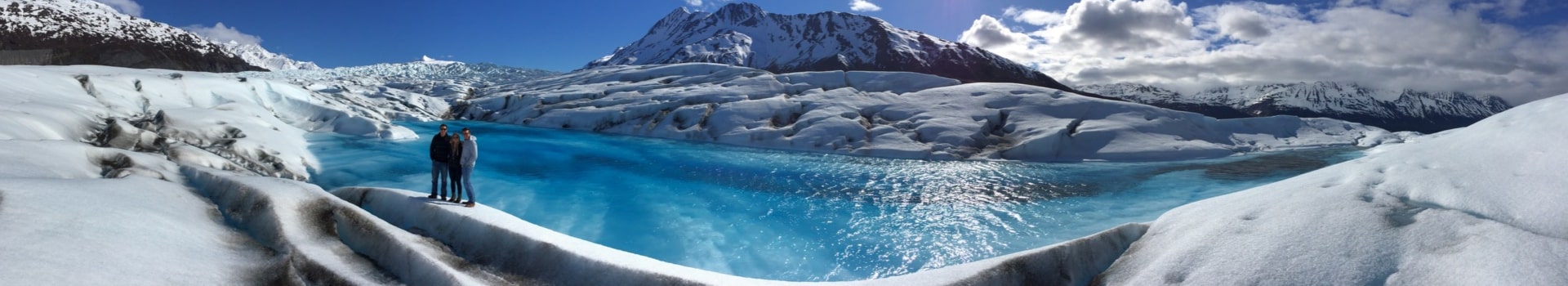
Glaciology and Climate Change Insights
Tracking Glacier Dynamics
Okay, so glaciers are like, really important indicators of climate change. The Alaska Satellite Facility (ASF) plays a big role in keeping tabs on them. Using Synthetic Aperture Radar (SAR), the ASF can monitor how glaciers are moving and changing over time. This is super useful because SAR can see through clouds and darkness, which is a big deal in places like Alaska where it’s often cloudy. We can get a clear picture of what’s happening to these icy giants, even when we can’t see them with our own eyes. This helps scientists understand how quickly glaciers are melting and how that meltwater might affect sea levels and local water resources. The University of Alaska Fairbanks is advancing climate change research through paleoclimatology, glaciology, and climate modeling.
Understanding Arctic Ice Melt
The Arctic is warming, like, twice as fast as the rest of the planet. That’s a problem. The ASF helps us understand what’s going on with the sea ice up there. SAR data can show us how much ice there is, how thick it is, and how it’s moving. This is important for a bunch of reasons. First, sea ice helps regulate the planet’s temperature by reflecting sunlight back into space. When it melts, that sunlight gets absorbed by the ocean, which warms things up even more. Second, a lot of animals, like polar bears and seals, depend on sea ice for their survival. If the ice disappears, they’re in trouble. Research at the University of Alaska Fairbanks highlights the extensive impacts of climate change on Alaska’s environment, particularly through studies in paleoclimatology and glaciology.
Contributing to Climate Models
All the data that the ASF collects on glaciers and sea ice is fed into climate models. These models are like super-complicated computer programs that try to predict what the climate will be like in the future. The more accurate data we put into these models, the better their predictions will be. And better predictions mean we can make better decisions about how to deal with climate change. It’s all connected. The ASF’s work is a key piece of the puzzle in understanding and addressing one of the biggest challenges facing our planet.
The ASF’s data is not just about numbers and charts; it’s about understanding the real-world impacts of climate change on communities and ecosystems. It helps us see the changes happening in our own backyard and around the world, and it gives us the information we need to take action.
Monitoring Natural Hazards with the Alaska Satellite Facility

The Alaska Satellite Facility (ASF) plays a vital role in monitoring various natural hazards, providing data that helps scientists and emergency responders understand and mitigate risks. ASF’s capabilities, particularly with Synthetic Aperture Radar (SAR), allow for continuous observation regardless of weather conditions or time of day. This is super important when you’re trying to keep tabs on things that can change quickly and unexpectedly.
Detecting Landslides and Subsidence
ASF data is instrumental in detecting subtle ground movements that can indicate potential landslides or subsidence. By using interferometric SAR (InSAR) techniques, scientists can measure ground deformation with millimeter-level precision. This is how it works:
- SAR satellites send radar signals to the ground.
- These signals bounce back to the satellite.
- Changes in the signal’s phase over time reveal ground movement.
This capability is especially useful in areas prone to landslides, like coastal Alaska, where thawing permafrost and heavy rainfall can trigger dangerous events. The land movement visualization tool being developed will be a game changer.
Assessing Volcanic Activity
Volcanoes are a constant threat in many parts of the world, and ASF data helps monitor volcanic activity in several ways. SAR can detect changes in a volcano’s shape, indicating magma movement beneath the surface. It can also measure the extent of lava flows and ash deposits after an eruption.
Here’s a quick rundown of how ASF helps:
- Detects pre-eruption deformation.
- Maps lava flow extent.
- Monitors ash cloud dispersal.
Mapping Flood Extents
Flooding is one of the most common and devastating natural disasters, and ASF provides critical data for mapping flood extents. SAR imagery can penetrate cloud cover and vegetation, allowing for accurate identification of flooded areas even in challenging conditions. This information is crucial for emergency response efforts, helping to direct resources to the areas that need them most. The ASF acquires remote-sensing data to help with this.
Here’s why it matters:
- SAR sees through clouds and vegetation.
- Provides accurate flood maps.
- Aids in effective disaster response.
ASF’s contribution to monitoring natural hazards is invaluable, providing data that helps protect communities and infrastructure from the impacts of these events. The ability to see through clouds and darkness with SAR makes it an indispensable tool for disaster management. The Barry Arm landslide is a prime example of an area under constant observation.
The Alaska Satellite Facility’s Contribution to Environmental Science
Forest Monitoring and Deforestation
The Alaska Satellite Facility (ASF) plays a big role in keeping an eye on forests. Using satellite data, we can see how forests are changing over time. This is super important for understanding deforestation, which is a major problem around the world. ASF’s data helps researchers and organizations track where forests are being cut down and how fast it’s happening. This information is used to make better plans for protecting forests and making sure they’re managed well. It’s like having a constant eye in the sky, helping us protect these important ecosystems. The UAF researchers journal publications are invaluable in this effort.
Coastal Erosion Studies
Coastal erosion is a serious issue, especially in Alaska. ASF’s satellite data helps us study how coastlines are changing. We can see how much land is being lost to the sea and how fast it’s happening. This is important for communities that live near the coast, as erosion can threaten their homes and livelihoods. The data from ASF helps scientists understand why erosion is happening and what can be done to protect coastlines. This information is used to develop strategies for managing coastal areas and protecting them from the effects of erosion.
Wildlife Habitat Mapping
Knowing where animals live is key to protecting them. ASF helps with wildlife habitat mapping by providing detailed images of the Earth’s surface. These images can show where different types of habitats are located, like forests, wetlands, and grasslands. Scientists can use this information to understand where animals live and how they use their habitats. This is important for making sure that wildlife has the space and resources they need to survive. The SNL database mine footprint dataset is a great resource for this.
ASF’s contribution to environmental science is pretty significant. By providing data and tools, they’re helping us understand and address some of the biggest environmental challenges we face. From tracking deforestation to studying coastal erosion and mapping wildlife habitats, ASF is making a real difference in how we protect our planet.
International Collaboration and Data Sharing
Fostering Global Scientific Partnerships
Okay, so the Alaska Satellite Facility (ASF) isn’t just doing its own thing up there in the Arctic. It’s a major player in a huge network of international scientific partnerships. Think of it like this: ASF is the cool kid who knows everyone at the global science party. These partnerships are super important because they allow scientists from all over the world to work together, sharing knowledge and resources to tackle some really big problems, like climate change and natural disasters. It’s all about teamwork making the dream work, you know? These partnerships help in space domain awareness operations.
Promoting Open Data Access
One of the coolest things about ASF is its commitment to open data access. Basically, they believe that the data they collect should be available to everyone, not just a select few. This means researchers, students, and even regular folks can get their hands on this information to study our planet. It’s like having a giant library of Earth observation data that’s open 24/7. This approach really helps speed up scientific discovery and innovation. The ASF DAAC made ALOS-2 ScanSAR data available through Earthdata.
Enhancing Research Capabilities Worldwide
ASF’s work isn’t just about collecting and sharing data; it’s also about helping other countries and organizations build their own research capabilities. They do this through training programs, workshops, and by providing access to their advanced tools and technologies. It’s like ASF is saying, "Here, take this knowledge and use it to make the world a better place!" This is especially important for countries that may not have the resources to develop their own satellite data processing facilities. By supporting these efforts, ASF is helping to create a more equitable and collaborative global research community. The network provides high-speed satellite-to-ground communication with ATLAS Space Operations.
Technological Advancements at the Alaska Satellite Facility

Innovations in Satellite Data Processing
The Alaska Satellite Facility (ASF) is always working on ways to make satellite data better and faster. One key area is improving how raw data is turned into usable information. They’re developing new algorithms and techniques to remove noise, correct distortions, and enhance the clarity of images. This means researchers and other users get more accurate and reliable data to work with. It’s not just about processing speed, but also about the quality of the final product. For example, they are working on ways to automate the processing of large datasets, which used to take a lot of time and effort. This automation helps speed up research and monitoring efforts.
Developing Advanced Analytical Tools
ASF isn’t just about getting the data; it’s also about helping people understand it. They’re creating new tools that make it easier to analyze satellite imagery. These tools include things like:
- Software for detecting changes in land cover over time.
- Algorithms for identifying specific features, like buildings or forests.
- Methods for combining data from different satellites to get a more complete picture.
These tools are designed to be user-friendly, so even people who aren’t experts in remote sensing can use them. The goal is to make satellite data accessible to a wider audience, so more people can use it to solve problems.
Future Directions in Earth Observation
ASF is looking ahead to the future of Earth observation. They’re exploring new technologies and techniques that could revolutionize the field. This includes things like:
- Using artificial intelligence to analyze satellite data. aviation safety enhancements
- Developing new sensors that can measure things like soil moisture and air quality.
- Working with other organizations to create a global network of Earth observation satellites.
The goal is to create a more comprehensive and timely picture of our planet, so we can better understand and address the challenges we face. They are also working on ways to make satellite data more accessible to people in developing countries, so they can use it to improve their lives. The Fairbanks Emergency Communications Center can benefit from these advancements. SkyFi and ICEYE’s synthetic aperture radar are also key players in this field.
Educational Outreach and Training by the Alaska Satellite Facility
The Alaska Satellite Facility (ASF) doesn’t just collect and distribute data; it’s also seriously invested in making sure people know how to use it. They put a lot of effort into educational programs and training, aiming to spread knowledge about remote sensing and Earth observation to a wide audience. It’s not just for scientists either; they want to get everyone from students to seasoned researchers involved.
Inspiring the Next Generation of Scientists
ASF knows that the future of Earth observation depends on getting young people excited about science and technology. They do this through a bunch of different programs aimed at students of all ages. For example, they might offer tours of the facility, where students can see firsthand how satellite data is collected and processed. They also participate in science fairs and other events, showcasing the cool things you can do with remote sensing. The goal is to spark an interest in STEM fields and show students that they can make a real difference in understanding our planet. The Geophysical Institute encompasses various research groups, including ASF, which allows for a broad range of educational opportunities.
Workshops and Training Programs
ASF offers a range of workshops and training programs for people who want to learn more about remote sensing and SAR data. These programs are designed for different skill levels, from beginners to advanced users. They cover everything from the basics of SAR imaging to more advanced techniques for data analysis and interpretation. The workshops often involve hands-on exercises, so participants can get practical experience working with real data. Plus, they bring in experts from around the world to share their knowledge and insights. If you are a forecaster, there are training modules available to update you on the capabilities of the JPSS/NOAA-20 satellite.
Building Capacity in Remote Sensing
ASF is committed to building capacity in remote sensing, both in the US and internationally. This means helping other organizations and countries develop their own expertise in using satellite data for research and applications. They do this through a variety of initiatives, such as providing training to scientists and policymakers in developing countries, sharing data and software tools, and collaborating on research projects. The Applied Remote Sensing Training (ARSET) program provides online and in-person training for all skill levels. By building capacity, ASF hopes to empower more people to use remote sensing to address important environmental and societal challenges. The Displacement Portal offers an InSAR-derived surface displacement dataset covering most of North America, providing valuable measurements for various applications. For example, there is an in-person ARSET training that covers TEMPO observations and their applications for air quality in the Western USA. If you are looking for foundational knowledge in Synthetic Aperture Radar (SAR) remote sensing, the University of Alaska Fairbanks offers an online course covering SAR imaging and interferometry concepts.
ASF’s educational outreach is about more than just teaching people how to use satellite data. It’s about fostering a community of researchers, educators, and policymakers who are passionate about using remote sensing to understand and protect our planet. By investing in education and training, ASF is helping to ensure that future generations have the skills and knowledge they need to address the challenges facing our world.
The Economic Impact of the Alaska Satellite Facility

The Alaska Satellite Facility (ASF) isn’t just about science; it’s also a significant economic driver, especially for Alaska. It’s easy to overlook the financial side of things when we’re talking about climate change and scientific discoveries, but ASF’s presence has a real impact on the state’s economy.
Supporting Alaskan Industries
ASF’s data and services are used by a surprising number of Alaskan industries. For example, companies involved in resource management, like fisheries and forestry, use satellite data to monitor changes in the environment. This helps them make better decisions about how to manage resources sustainably. Also, infrastructure projects, like pipelines and roads, rely on satellite imagery to plan and monitor construction, especially in remote areas. This can save time and money by identifying potential problems early on. The Landsat data economic benefits are significant across various sectors.
Job Creation and Local Development
ASF directly employs a number of people in Alaska, from scientists and engineers to data specialists and support staff. These are good-paying jobs that help support families and communities. Beyond direct employment, ASF also supports local businesses through contracts for services like IT support, maintenance, and supplies. This creates a ripple effect, boosting the local economy. The presence of ASF also attracts other high-tech companies and research institutions to the state, further contributing to economic growth. The Aleut Corporation is working to establish a satellite launch facility in Alaska.
Driving Innovation in Geospatial Technology
ASF is at the forefront of geospatial technology, constantly developing new tools and techniques for processing and analyzing satellite data. This innovation has a spillover effect, benefiting other industries and creating new business opportunities. For example, companies are developing new software and applications that use ASF’s data to provide services like precision agriculture, disaster response, and urban planning. This helps to create a more diverse and resilient economy. The partnership between Aleut Corporation and SpinLaunch aims to provide a sustainable method for deploying satellites. The use of machine learning to map Alaskan infrastructure reveals that damage from thawing permafrost could lead to a doubling of costs by 2050.
It’s important to remember that the economic impact of ASF goes beyond just the numbers. It’s about creating a more sustainable and resilient economy for Alaska, one that is based on innovation, collaboration, and a commitment to understanding and protecting our environment. And that’s something that benefits everyone.
The Alaska Satellite Facility helps our state’s economy in big ways. It creates jobs and brings in money by working with other groups. This facility is super important for Alaska’s future, helping us grow and stay strong. Want to see how we make a difference? Check out our website to learn more about our work and its impact.
Wrapping Things Up: The ASF’s Big Impact
So, as we’ve seen, the Alaska Satellite Facility isn’t just some building up north. It’s a really important place that helps us understand our planet better. They collect all this satellite data, which lets scientists see things like how glaciers are changing or what’s happening with our forests. This information helps us make smart choices about the environment and how we live. It’s pretty cool how a place in Alaska can give us such a clear picture of Earth, helping us figure out what’s going on and what we need to do next.
Frequently Asked Questions
What’s the big deal about the Alaska Satellite Facility?
The Alaska Satellite Facility (ASF) is super important because it helps us watch Earth from space. It’s like a main hub for getting and sharing information from satellites, which helps scientists all over the world learn more about our planet.
What is Synthetic Aperture Radar (SAR) and why is it useful?
SAR, or Synthetic Aperture Radar, is a special way to take pictures of Earth. Unlike regular cameras that need light and clear skies, SAR uses radio waves. This means it can ‘see’ through clouds, fog, and even in the dark, giving us a clear view of the ground no matter what.
How does ASF Vertex help people use satellite data?
ASF Vertex is a tool that makes it easy for people to get and look at SAR data. It helps scientists and others use the information from SAR satellites without needing to be super techy. This makes it simpler to study things like earthquakes or how cities are growing.
How does the ASF help us learn about climate change?
ASF helps us understand climate change by keeping an eye on glaciers and ice. They can see how fast glaciers are melting and how the ice in the Arctic is changing. This information is key for scientists to build better models and predict what might happen to our climate.
Can the Alaska Satellite Facility help with natural disasters?
The ASF plays a big role in watching for natural dangers. They can spot things like landslides, ground sinking, and even volcanic activity. They also help map out areas affected by floods, which is really helpful for safety and planning.
Does the ASF contribute to protecting our environment?
Yes, ASF helps a lot with environmental science. They track forests to see if they’re being cut down, study how coastlines are changing, and even map out where different animals live. This helps us protect our environment.
How does the ASF work with other countries?
ASF works with other countries and shares its data freely. This helps scientists everywhere work together, share what they find, and make bigger discoveries about Earth. It’s all about teamwork!
What new things is the Alaska Satellite Facility working on?
The ASF is always coming up with new and better ways to process satellite data and create smart tools for analysis. They are always looking ahead to improve how we observe Earth from space.