Alaska, often dubbed “The Last Frontier,” is a land of mystery and wonder. It’s not just a state; it’s an experience. When you look at a map of Alaska and the USA, you’re not just seeing lines and borders. You’re diving into a world of towering mountains, sprawling wilderness, and rich history. This article is your guide to understanding the unique geography, cultural heritage, and economic landscapes that make Alaska such a fascinating place. From the bustling streets of Anchorage to the serene beauty of Denali, join us as we explore what makes this state truly special.
Key Takeaways
- Alaska’s geography is unique, with vast wilderness areas and towering mountain ranges.
- Historical maps of Alaska show its evolution from a remote territory to a vital state in the USA.
- Major cities like Anchorage and Juneau offer a blend of urban life and natural beauty.
- Alaska’s natural wonders, like Denali and its glaciers, are major attractions.
- Cultural insights reveal a rich tapestry of Native Alaskan heritage and modern influences.
Understanding the Geography of Alaska and the USA

The Unique Position of Alaska
Alaska is like no other state in the USA. It’s way up in the northwest corner of North America, all by itself, separated from the rest of the country by Canada. This means it’s got a unique vibe and landscape. Alaska is huge, covering more land than Texas, California, and Montana combined. It’s surrounded by the Arctic Ocean to the north and the Pacific Ocean to the south, with the Bering Sea to the west. This isolated position gives Alaska its wild charm and makes it a place of extremes.
Here’s a quick look at some key geographical features:
- Borders: Shares a border with Canada (Yukon and British Columbia).
- Water: Flanked by the Arctic and Pacific Oceans.
- Size: Largest state in the USA by land area.
Major Geographical Features
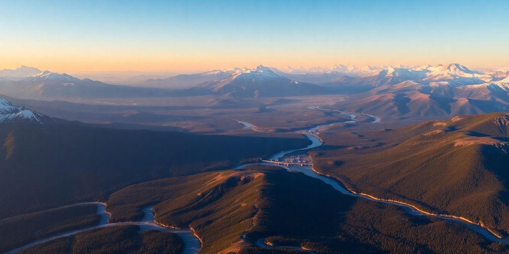
Alaska’s landscape is nothing short of spectacular. It’s home to Denali, North America’s tallest peak, and has over 3,000 rivers and 3 million lakes. The state’s coastline stretches for about 6,640 miles, making it the longest in the US. You can find everything from icy glaciers to lush forests and tundra.
Here’s a rundown of some major features:
- Mountains: Includes the Alaska Range and the Brooks Range.
- Water Bodies: Features numerous rivers and lakes, like the Yukon River.
- Coastline: Extensive and varied, with fjords and islands.
Comparing Alaska with the Contiguous USA
When you stack up Alaska against the contiguous USA (the "Lower 48"), the differences are striking. While the contiguous states have a mix of urban and rural areas, Alaska is mostly wilderness. The population density is super low compared to states like New York or California. Plus, the climate is a whole different ball game, with long, dark winters and short, bright summers.
Here’s a quick comparison:
- Population Density: Alaska has the lowest in the USA.
- Climate: Arctic and subarctic, unlike the more temperate climates in the Lower 48.
- Urban vs. Rural: Predominantly rural with vast natural areas.
Alaska’s geography is a wild tapestry of mountains, rivers, and rugged coastline, offering a stark contrast to the contiguous USA’s more developed and populated landscapes. It’s a place where nature reigns supreme, and adventure awaits around every corner.
Historical Maps: Tracing the Evolution of Alaska and the USA
Early Cartography of Alaska
Back in the day, before Alaska became a state, maps were a bit of a treasure hunt. Early explorers and cartographers had their work cut out for them, trying to make sense of Alaska’s vast and rugged terrain. Russian cartographers were among the first to chart these lands, and their maps were often more art than science. You’d find exaggerated coastlines and missing mountain ranges. But hey, it was a start! These early maps were crucial for fur traders and explorers who braved the unknown.
The Impact of Statehood on Mapping
When Alaska became a state in 1959, mapping took on a whole new level of importance. Suddenly, it wasn’t just about exploration; it was about integration into the United States. Statehood brought a wave of modern mapping techniques, as the government needed accurate maps for everything from building infrastructure to managing resources. Roads, towns, and cities started appearing on maps with more precision. This period marked a shift from hand-drawn sketches to more precise and reliable maps.
Modern Mapping Techniques
Fast forward to today, and mapping in Alaska has gone high-tech. With satellite imagery and GPS, maps are now incredibly detailed. You can zoom in to see individual streets in Anchorage or the winding trails in Denali National Park. Digital maps have transformed how we explore and interact with the world. Interactive features let you plan trips, explore remote areas, and even spot wildlife from the comfort of your home. It’s a far cry from those early days of guesswork and artistic license.
Maps of Alaska have evolved dramatically over the years, reflecting not just technological advancements but also the changing needs and priorities of those who call this vast land home.
Exploring Alaska’s Major Cities and Towns
Anchorage: The Urban Heart
Anchorage is the largest city in Alaska and acts as the state’s vibrant urban center. It’s a place where modern living meets the wild. Surrounded by mountains and water, Anchorage offers a unique blend of outdoor adventures and city comforts. Anchorage is not just a city; it’s a gateway to the Alaskan wilderness. Whether you’re interested in exploring the Chugach Mountains or enjoying the local arts scene, Anchorage has something for everyone. The city is also a major hub for transportation, making it an ideal starting point for further Alaskan exploration.
Juneau: The Political Center
Juneau, the capital of Alaska, is nestled between Mount Juneau and the Gastineau Channel. It’s a city that blends political importance with natural beauty. Juneau is only accessible by boat or plane, which adds to its charm and isolation. The city is known for its stunning landscapes, including the nearby Mendenhall Glacier. Visitors can explore the state’s political heart while enjoying the luxury of nature all around.
Fairbanks: The Northern Hub
Fairbanks is often called the "Golden Heart City" and serves as a key hub in the northern region of Alaska. It’s a place where you can experience the extremes of Alaskan weather, from the midnight sun in summer to the aurora borealis in winter. Fairbanks is a gateway to the Arctic and offers unique cultural experiences, including the chance to learn about the indigenous peoples of Alaska. The city’s location provides easy access to the vast wilderness of the interior, making it a perfect base for exploring the northern reaches of the state.
The Natural Wonders Highlighted on the Map of Alaska
Denali: The Tallest Peak
Denali, standing at a staggering 20,310 feet, is the tallest peak in North America. It’s not just a mountain; it’s a symbol of Alaska’s wild beauty. Climbing Denali is a bucket-list item for many adventurers, but even if you’re not scaling its heights, the views from below are awe-inspiring. The mountain is part of the larger Denali National Park, a protected area that offers a peek into Alaska’s diverse ecosystems. Visitors can explore the park through guided tours, hiking trails, or even scenic flights for a bird’s-eye view.
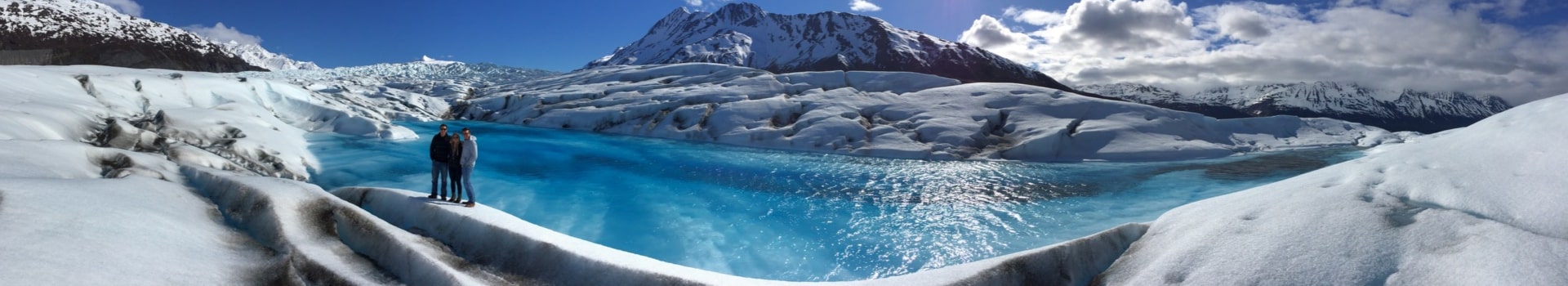
The Glaciers and Fjords
Alaska’s glaciers are like nature’s frozen sculptures, with each one telling a story of time and transformation. The Hubbard Glacier, in particular, is a must-see. It’s the largest tidewater glacier in North America and is famous for its dramatic calving displays. Watching massive chunks of ice crash into the sea is a spectacle you won’t forget. The fjords, like those in Prince William Sound, offer serene beauty and are perfect for kayaking or boat tours. A helicopter tour here, with a glacier landing, provides a thrilling way to experience these icy wonders up close.
Alaska’s Vast Wilderness
The sheer vastness of Alaska’s wilderness is mind-blowing. Spanning over 663,300 square miles, the state is larger than Texas, California, and Montana combined. This expansive terrain is home to countless rivers, lakes, and mountains, making it a paradise for outdoor enthusiasts. The Knik Valley, near Anchorage, is a prime example of Alaska’s untouched beauty, offering hiking, biking, and fishing opportunities. Wildlife is abundant, with moose, bears, and eagles commonly seen, adding to the sense of adventure and exploration that defines Alaska.
Cultural Insights Through the Map of Alaska and the USA
Alaska’s cultural landscape is deeply rooted in the traditions of its Native peoples. The history of Indigenous Peoples in Alaska is intertwined with the land, notably through their connection to salmon, which has been central to their culture for over 12,000 years. This rich heritage is not just about survival but a profound relationship with nature.
Alaska’s map is a tapestry of Native tribes, each with its unique traditions and stories. A historical map compiled by W. H. Dall in 1875 highlights the geographical presence and cultural significance of these tribes, offering a glimpse into their enduring legacy. This map is a testament to the diverse cultural tapestry that defines Alaska.
Anchorage and Fairbanks are vibrant cities where modern cultural influences meet traditional values. These urban centers are melting pots of cultures, showcasing a blend of Native traditions and contemporary lifestyles. The cosmopolitan vibe of Anchorage is a testament to Alaska’s evolving cultural landscape.
In recent years, efforts like Permafrost Pathways have been pivotal in restoring traditional place names on maps, empowering communities to reclaim their history and shape their future. This initiative highlights the ongoing dialogue between past and present, emphasizing the importance of preserving cultural identity in a rapidly changing world.
Across Alaska, cultural landmarks stand as reminders of the state’s rich heritage. From ancient totems to modern art installations, these sites offer insights into the diverse cultural influences that have shaped the region.
- Totem Bight State Historical Park: A collection of restored totem poles and a traditional clan house.
- Alaska Native Heritage Center: A hub for learning about Native Alaskan cultures through exhibits and performances.
- Anchorage Museum: Showcasing art and history, it provides a window into Alaska’s past and present.
These landmarks are not just tourist attractions but vital pieces of Alaska’s cultural puzzle, each telling a story of the people who call this land home. They invite visitors to explore and appreciate the rich tapestry of Alaskan culture.
Economic Landscapes: Resources and Industries

Oil and Gas Exploration
Alaska’s economy heavily leans on the oil and gas industry. This sector is a major player, not only fueling the state’s energy needs but also driving employment and revenue. The exploration and extraction activities primarily occur in the North Slope and Cook Inlet areas. These regions are rich in oil reserves, contributing significantly to the state’s economic output.
- The North Slope is known for its vast oil fields, including Prudhoe Bay, one of the largest oil fields in North America.
- Cook Inlet, while smaller, plays a crucial role in natural gas production.
- The industry supports thousands of jobs, from direct extraction roles to ancillary services.
Fishing and Maritime Activities
Fishing is another cornerstone of Alaska’s economy. With its extensive coastline and rich marine biodiversity, the state is a leader in commercial fishing. This industry not only supplies a significant portion of the world’s seafood but also sustains local communities.
- Salmon, crab, and halibut are among the most valuable catches.
- The fishing industry supports both commercial and subsistence fishing practices.
- Maritime activities extend to shipping and transportation, crucial for remote communities.
Tourism and Adventure
Tourism in Alaska is an adventure waiting to happen. The state’s natural beauty attracts visitors from around the globe, eager to experience its wilderness and wildlife. This sector is vital for local economies, particularly in smaller towns and rural areas.
- Popular activities include wildlife viewing, hiking, and glacier tours.
- Cruise ships bring thousands of visitors each year, boosting local businesses.
- Tourism provides seasonal employment, supporting guides, hospitality workers, and more.
Despite the challenges posed by its remote location and harsh climate, Alaska’s economic landscape is diverse and dynamic, with each sector contributing to the state’s unique identity and resilience. The interplay between natural resources and industries like oil and gas and fishing showcases the state’s dependence on its environment while highlighting the need for sustainable practices.
Navigating the Waterways of Alaska
The Inside Passage
The Inside Passage is a must-see for anyone visiting Alaska. This scenic waterway stretches along the southeast coast, offering breathtaking views of wildlife-filled fjords and lush islands shaped by ancient glaciers. Most Alaskan cruises include this route, making it a popular choice for tourists. However, for those seeking to explore Alaska’s watersheds in greater detail, special expedition cruises provide a closer look at the unique ecosystems and water flow, enhanced by modern 3D mapping technology.
Major Rivers and Lakes
Alaska is home to an impressive network of rivers and lakes, with over 3,000 rivers and 3 million lakes scattered across the state. The Yukon River is one of the longest, stretching over 1,980 miles. It offers a glimpse into the state’s vast wilderness and is a favorite for adventurous travelers. Lake Iliamna, the largest lake in Alaska, provides opportunities for fishing and wildlife watching. Exploring these waterways gives visitors a chance to connect with the natural beauty of Alaska.
Coastal Highlights
Alaska’s coastline is a rugged and awe-inspiring landscape, featuring over 34,000 miles of shoreline. The Navigation by radar is particularly useful here, given the high relief of the coastline. Prince William Sound, with its calm waters and dense concentration of tidewater glaciers, is a highlight for many visitors. Here, you can spot seals, otters, and even whales. The Aleutian Islands, though more challenging to navigate due to choppy waters, offer a unique adventure for those willing to brave the journey. These coastal areas not only showcase the raw beauty of Alaska but also highlight the importance of waterways management in ensuring safe and efficient maritime operations.
Alaska’s waterways are a testament to the state’s untamed beauty. Whether you’re cruising through the Inside Passage or exploring the vast network of rivers and lakes, the experience is unforgettable. The blend of stunning landscapes and diverse wildlife makes Alaska’s waterways a true natural wonder.
Wildlife and Natural Habitats on the Map
Protected Areas and National Parks
Alaska is home to some of the most stunning protected areas and national parks in the United States. Denali National Park is a prime example, where visitors can encounter a variety of wildlife, including grizzly bears, moose, and wolves. The park offers a unique opportunity to explore its rich biodiversity with 39 species of mammals and 169 species of birds. The vast landscapes provide a refuge for these animals, ensuring their survival in their natural habitats.
Marine Life and Bird Watching
The coastal regions of Alaska are teeming with marine life. The Alaska Wildlife Conservation Center plays a crucial role in preserving these species. Along the Inside Passage, you might spot sea otters, orcas, and humpback whales. Bird watchers can revel in the sight of bald eagles soaring above, especially along the coastlines and rivers where they are most prevalent. Alaska’s waterways are a sanctuary for these creatures, offering a glimpse into the state’s vibrant marine ecosystem.
Wildlife Corridors
Alaska’s vast wilderness is crisscrossed by wildlife corridors that are essential for the migration of species like caribou and Dall sheep. These corridors are vital for maintaining genetic diversity and ensuring the survival of various species. The Alaska Wildlife Alliance is dedicated to protecting these pathways, engaging citizens in advocacy and education efforts. These corridors are not just passageways but lifelines that support the ecological balance within the state.
Alaska’s natural habitats are a testament to the state’s commitment to conservation. The intricate web of protected areas, marine sanctuaries, and wildlife corridors paints a picture of a land where nature thrives in its purest form.
Travel and Transportation Routes in Alaska and the USA
Major Highways and Roads
Alaska’s road network is a mix of rugged terrain and scenic views. The Alaska Highway, also known as the ALCAN Highway, is a key route connecting the lower 48 states to Alaska. It’s a journey through breathtaking landscapes, offering a peek into the vast wilderness. Other significant routes include the Cassiar Highway and the Coastal Route, each providing unique vistas and travel experiences.
Air Travel and Airports
For many, flying is the most practical way to travel between Alaska and the contiguous United States. Anchorage, the state’s largest city, serves as a major hub. A flight from Anchorage to Seattle takes about 3.5 hours, making it a quick option for travelers. However, some adventurers choose to drive, a journey that spans over three days through Canada’s Yukon and British Columbia before reaching the U.S. border.
Rail and Sea Connections
The Alaska Railroad offers a scenic way to explore the state, with routes extending from Anchorage to Fairbanks and Seward. This rail line is a lifeline for both locals and tourists, providing access to some of Alaska’s most stunning landscapes. Additionally, the AK Marine Highway extends ferry routes from Bellingham, Washington, to Dutch Harbor in the Aleutian Islands. This network of ferries is crucial for reaching remote areas and enjoying the state’s coastal beauty.
Traveling through Alaska is an adventure in itself. Whether by road, air, rail, or sea, each mode of transportation offers a unique perspective on this vast and wild frontier. The journey is as much a part of the experience as the destination, revealing the state’s untamed beauty and diverse landscapes.
The Role of Technology in Modern Mapping
Digital Mapping Innovations
Maps have come a long way from the days of parchment and ink. Today, digital mapping is a game-changer, making it easier to create, share, and use maps. Digital mapping innovations have transformed how we see our world, allowing us to view detailed maps on our phones or computers. These maps are not just static images; they are interactive, letting us zoom in, search for locations, and even get real-time updates on traffic or weather conditions. This technology is especially useful in places like Alaska, where the terrain can be challenging to navigate. With digital maps, adventurers and researchers can explore remote areas safely and efficiently.
Satellite Imagery and GPS
Satellite imagery and GPS have opened up new possibilities in mapping. Satellites orbiting the Earth capture high-resolution images, providing accurate and up-to-date information about the planet’s surface. This data is crucial for everything from urban planning to environmental monitoring. In Alaska, for instance, satellite imagery helps track changes in the landscape, such as melting glaciers or shifting wildlife habitats. GPS, on the other hand, allows us to pinpoint our location anywhere on Earth, which is vital for navigation in vast, remote areas. Together, these technologies provide a comprehensive view of our world, making it easier to understand and manage.
Interactive Map Features
Interactive maps are not just for finding directions anymore. They offer a wealth of information at our fingertips. With features like zoom, search, and layer options, users can customize their map experience to suit their needs. For example, a hiker in Alaska might use an interactive map to find trails, check elevation changes, and even see photos from other hikers. These maps can also display real-time data, such as weather conditions or wildlife sightings, making them invaluable tools for planning outdoor adventures. Interactive maps make exploring the world more accessible and engaging than ever before.
Technology has turned maps into dynamic tools that not only show us where we are but also help us understand the world around us. Whether you’re navigating the busy streets of a city or the wild landscapes of Alaska, modern mapping technology is your guide.
Alaska’s Climate Zones and Weather Patterns

Arctic and Subarctic Conditions
Alaska is a land of extremes, with its climate zones ranging from temperate rainforests in the Southeast to the icy Arctic tundra in the North Slope. The northern regions experience long, harsh winters with temperatures often plummeting below freezing for months on end. In contrast, the southeastern parts enjoy milder, wetter conditions. The state’s unique position means it experiences some of the most diverse weather patterns in the world. In Arctic Alaska, climate change is causing the sea ice to melt and permafrost to thaw, leading to more frequent extreme weather events.
Seasonal Variations
Alaska’s seasons are distinct and dramatic. Winters are long and dark, especially in the northern areas, while summers bring endless daylight, known as the Midnight Sun. Spring and autumn are short but can be quite unpredictable. Recent trends show that rain is increasingly replacing snow in the fall, and freezing rain is becoming more common in winter. Summer temperatures can reach into the 70s, but rain is still frequent, especially in the coastal regions.
Impact on Travel and Living
Living in Alaska requires adapting to its unique climate challenges. The weather can significantly affect daily life, from transportation to outdoor activities. The weather forecast often includes a mix of rain and snow, with temperatures fluctuating rapidly. These conditions can make travel tricky, particularly in remote areas. Despite these challenges, many residents embrace the natural beauty and opportunities for adventure that the Alaskan climate offers. The dramatic shifts in weather also influence the state’s flora and fauna, creating a dynamic and ever-changing landscape.
Alaska is home to a variety of climate zones, each with its own unique weather patterns. From the chilly tundra to the lush coastal rainforests, the state’s diverse environments create fascinating weather changes. If you’re curious about how these climates affect the stunning landscapes and wildlife, visit our website for more information and to plan your next adventure!
Conclusion
Wrapping up our journey through Alaska and the broader USA, it’s clear that this vast region is a treasure trove of natural wonders and cultural richness. From the icy peaks of Denali to the bustling streets of Anchorage, Alaska offers a unique blend of adventure and tranquility. The maps we’ve explored not only guide us through the geographical intricacies but also invite us to delve deeper into the stories and histories that shape this incredible state. Whether you’re planning a visit or just dreaming from afar, Alaska’s allure is undeniable. It’s a place where the wilderness whispers secrets of the past and promises of the future. So, whether you’re an intrepid explorer or a curious traveler, the Last Frontier awaits with open arms, ready to share its beauty and mystery.
Frequently Asked Questions
What makes Alaska different from the rest of the USA?
Alaska is unique because of its location, far from the contiguous United States. It has vast wilderness, diverse wildlife, and extreme weather conditions, making it a unique place to explore.
Why is Alaska called “The Last Frontier”?
Alaska is known as “The Last Frontier” due to its remote location, rugged landscape, and the sense of adventure it offers. It was one of the last areas in the USA to be settled and explored.
What are some must-see natural wonders in Alaska?
Some must-see natural wonders in Alaska include Denali, the tallest peak in North America, the stunning glaciers and fjords, and the expansive wilderness areas filled with unique wildlife.
How does Alaska’s climate affect daily life?
Alaska’s climate, which ranges from Arctic in the north to milder conditions in the south, impacts daily life significantly. Residents must adapt to long, harsh winters and short, mild summers.
What role does wildlife play in Alaska?
Wildlife is a big part of Alaska’s identity. The state is home to diverse animals like bears, moose, and whales. Many people visit Alaska to experience its rich wildlife and natural habitats.
How important is oil and gas to Alaska’s economy?
Oil and gas are crucial to Alaska’s economy, providing jobs and revenue. The state is rich in natural resources, which play a significant role in its economic landscape.
What are some popular ways to travel around Alaska?
Traveling in Alaska can be an adventure. People often use cars, planes, and ferries to get around. The vast distances and challenging terrain make travel unique in this state.
How has technology changed the way we map Alaska?
Technology has revolutionized mapping in Alaska. Digital maps, satellite imagery, and GPS have made it easier to explore and understand the state’s complex geography.